Sunday, September 30, 2007

How to Deal With Unwanted Government Advertising

So you get this in your mail...

Government Propaganda

I bet you a dollar that you're not happy. There could be several reasons why. Maybe you don't have kids. Maybe you think the mailout is a waste of your tax money. Maybe you view the whole affair as a pathetic attempt to save a government in terminal decline. Maybe you don't like censorship. Maybe you think it will slow down your browsing. Maybe you feel you've forgotten more about computers than Helen Coonan has ever learnt. Or maybe you're like me: all of the above. What to do?

Prepare to mail it back - that's what Australia Post is for! Don't just add "Return to Sender", as I did with the anti-drugs ad. Address it to the Office of Prime Minister. That's where the pamphlet originated, after all. So jot this down on the other side. (You may have to rip the plastic. That's ok.)

The Hon John Howard MP
Prime Minister
Parliament House
CANBERRA ACT 2600

Don't just add 'Return to Sender'.

Add a personal note. (Please, no abuse is necessary!)

Let Johnnie feel the love!

Mail it back.

God bless Australia Post

Done! And of course, this tactic will work with the next government that comes along.

Sunday, September 16, 2007

Google Election 2007

Herbert

Looking swell, but what wrong with this picture?

Two posts ago, I had AEC Electoral Divisions in Google Earth - Part I. It linked six Google Earth Maps that showed the electoral divisions for all the territories and four of the six states. They weren't very flash - all they showed were the boundaries, plus a little bit of metadata. Still, I was a little proud. I had generated and tweaked them from the Australian Electoral Commission mapping data myself. It was my first post in six months. I even planned on a sequel - linking the equivalents for Victoria and NSW. To my dismay, I've been trumped by Google itself. Witness their Australian Federal Election 2007 site yourself, view their maps on your Browser, or even download it onto your Google Earth desktop.

My reactions were mixed when I learned about it on Friday - dismay and annoyance at my efforts superseded, yet admiration for their product, plus relief in that I didn't have to add the extra maps, yet a niggling feeling that I should provide them for completeness anyway. I haven't made up my mind, but I doubt there will be no AEC Google Earth Part II post from me.

I'll start with the strengths of Google's Federal Election maps, and there are many. Party allegiance is shown by colour coding; they're more colourful than my maps. In addition, users can learn seat information and candidate lists 
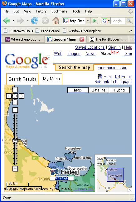
from clicking on the icons. Using the map above, what can a user learn?

The seat in yellow is Kennedy, held by independent Bob Katter with a margin of 18.8%. That's very safe. On the right in green is Dawson, held by National De-Anne Kelly with a margin of 10%. That's safe. In the middle in blue is Herbert, with Liberal Peter Lindsay holding it by 6.2%. That's safe-ish... well, not that safe, considering how hopeless the Liberals are doing at the moment. I actually had to drag to the left and right a little to extract most of this information, but still, the maps are wonderful. 

Unfortunately, there are problems with precision. Google sometimes isn't that certain as to where electoral boundaries stop. Take a look at the map again. See the island in white? That's Palm Island, an Aboriginal reserve. According to the AEC, it's clearly part of Herbert. By its lack of colouring, Google evidently considers it terra nullius - no voters, and hence no electoral district covering it. And what an unhappy history that island has had - originally used as a penal reserve for indigenous Australians, high unemployment, low life expectancy, a recent death in custody and ensuing riots. Having the whole island disenfranchised by Google doesn't help either.

I put the omission down to cluelessness or laziness, rather than maelevolence or racism. They've done the same mistake with Rottnest island (which should be part of Fremantle). Still, this leads up to my next problem - where do I go to get these mistakes corrected? There are lots of links to YouTube blather, but I do not see any clear feedback form on Google's site. Perhaps they don't care. Perhaps they should. I think the only think I can do is contact them on their Google Blog email, and leave it from there.

UPDATE: I got this in comments:

Thanks for pointing this out. It's a technical issue with the minimum specified polygon size in the KML. We've fixed it for Palm Island and Rottnest (where I spend many Uni summer holidays) should be correctly shaded soon.

Rob
Google Australia

I checked it out today. They have fixed the colours for those islands, and some islets nearby too. Good work, Google.

Monday, September 10, 2007

Beattie's gone

It was the 13th of June, 1998. It was the Medieval Faire in Musgrave Park, and the patrons were drunker than usual, and gloomier than the norm. But that was to be expected. There was a specter haunting the park: the specter of Pauline Hanson. It was also the day of the state election, and the polls were predicting a strong result for her new, virgin One Nation Party. Reports were coming in from the bush, - especially the festival goers who had travelled in from the country. They knew how popular she was. To be honest, I can't remember much of that festival apart from the wariness and the political conversations. And the beer. Lots of beer. 

My real concern at the time was: what if One Nation held the balance of power? Or worse: joined in some sort of coalition government? To be honest, the real concern I remember having with them was that they would rollback the decriminalisation of homosexuality. Not that the Liberals and Nationals tried that under Borbidge, but One Nation sounded like the sort of dickheads that would wear their base, unreconstructed prejudices with pride.

It was the next few days that the results came in. Out of an assembly of 89: 43 an unholy melange of Liberals, Nationals, and One Nation Party personnel. 2 independents, with one - Liz Cunningham - a little bit too close to the Nationals for my taste. The other - Peter Wellington - a pretty decent man. And 44 Labor people lead by one Peter Beattie - then better known for backing the CJC and getting up Wayne Goss's nostrils. It was a hung parliament. Fortunately, Wellington gave the nod to Beattie, and he became premier.

And if Labor had got 43, or 42: what would have happened? I don't really know. Could there have been a coalition between the "Conservatives"? More to the point - would anyone Labor have done better that then greenhorn premier like Beattie? In 1998, I doubt it. Certainly not Wayne "Kill all the koalas" Goss, and not the seriously right wing "Old Guard" that Beattie battled in the eighties. I also remember respecting Beattie for sticking up for no preference deals with One Nation - but that ended up winning him five seats in the city from the Liberals. There were - and are - a lot of Liberal voters who despise what Pauline Hanson stood for.  

Fortunately, that was the high-water mark for One Nation. As backbenchers, they bitched, and squabbled, and split into eleven little factions - one for each member of the party. By the time of the next election - 2001 - only four or five of them re-took their seats, and mostly as independents. 

This Thursday, Peter Beattie will step down as Premier of Queensland. I'm a little sorry to see him go. It's not that I saw much of him; I spent almost half of his tenure overseas. But I'm glad he got the job in the first place, and I can name the reason why: Pig Iron Pauline. Thank you, Peter, for helping nip that nonsense in the bud.

Elsewhere: Mark Bahnish's take on what Beattie's departure means for the Federal Election. (Good for Rudd, it seems.)

Friday, September 07, 2007

AEC Electoral Divisions in Google Earth - part I

The following links should be to Google Earth maps of Australian Electoral Divisions. Victoria and NSW are coming soon. For now, here's the rest.

But there's a catch. They're generated from official AEC GIS data. I can generate it, and I believe I share it as well, but one condition of using the GIS data is that I also have to pass along the following copyright notice. (XXXX stands for the relative state or territory - not the beer.)

This product (XXXX Electoral Divisions for Google Earth) incorporates data that is: © Commonwealth of Australia (Australian Electoral Commission) 2007

The Data (Commonwealth Electoral Boundaries (2007)) has been used in XXXX Electoral Divisions for Google Earth with the permission of the Australian Electoral Commission. The Australian Electoral Commission has not evaluated the Data as altered and incorporated within XXX Electoral Divisions for Google Earth, and therefore gives no warranty regarding its accuracy, completeness, currency or suitability for any particular purpose.

Limited End-user licence provided by the Australian Electoral Commission: You may use XXXX Electoral Divisions for Google Earth to load, display, print and reproduce views obtained from the Data, retaining this notice, for your personal use, or use within your organisation only.

I'll get around to the other states in the next few days. Have fun.